Ribbleton Lane and New Hall Lane
These two roads run not-quite parallel out of Preston, heading east, to Longridge and Blackburn respectively. I am going to head west down Ribbleton Lane, then back east along New Hall Lane.
Ribbleton Lane
The road starts at the junction with Blackpool Road - it is Ribbleton Avenue east of that.
The first pub was on the right, the Old England. As I write, this is visible in Google Street View, depending on the angle you look from. it was recently demolished, so more recent angles do not show it.
A bit further along on the left, the next set of lights in fact, was The Skeffington Arms, on Skeffington Road; now converted to accommodation. When I lived in the area I paid rent to an estate agent on the other side of the road - which has also gone - and sometimes came here for a drink afterwards. This was the mid-nineties, and it was pretty run down then.

The Derby Inn was on the junction with Wilbraham Street. I do not recall this being open when I lived around here. Now a barbers, but you can see what it looked like here.

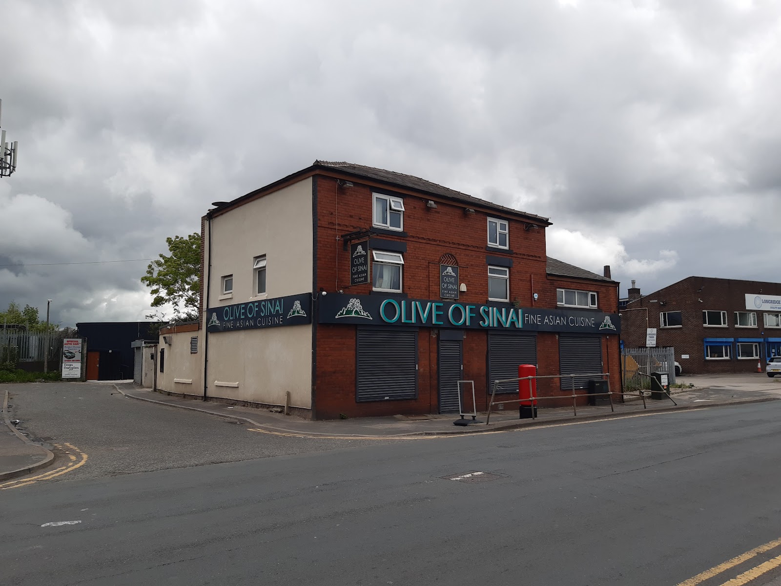
The Fox and Grapes was opposite Deepdale Mill Street, image here.
Heading up Deepdale Mill Street, there is St Luke's church off to the right.

Going slightly off-piste, Fletcher Road is parallel to Ribbleton Lane, and home to Beech's Fine Chocolates. This is a family business operating out of the same factory for over 100 years, though I think the frontage photographed is not quite that old.

Back to Ribbleton Lane, from around Deepdale Mill Street onwards, most of the area was levelled in the sixties. There were numerous pubs along the way.
Third Duke Of Lancasters Own, number 157, north side on the corner of Deepdale Mill Street.
Birchalls Arms, 150, south side, nearly opposite the New Sun.
New Sun Inn, 133, north side, corner of Morgan Street.
Guild Inn, 126, south side, corner of Ribbleton Place.
Rose Inn, 119, north side, opposite the Guild, corner of Young St. This one closed in 1913 when license was refused.
Albert Hotel, 101, north side, corner of Irving Street.
Star Hotel, 73, north side, corner of Almond St. This became Star Bakery in the 50s, but was demolished with the rest in the sixties.
Old Oak, 63, north side, corner St Mary's Street North.
A bit further on was the County Arms on the corner with Deepdale Road, which closed ion 2006 and was demolished a year later. It is now car park. Image here.
Opposite the County Arms is HMP Preston. Wiki tells me there has been a prison on the site since 1790, though this building dates from the late 1800s. It closed in 1931, had a spell as a military prison from 1939 to 1948, before becoming a civilian prison again. In 2001 and 2004 it had the sorry distinction of being the most overcrowded prison in the country.
Stanley Street
We go briefly along Stanley Street, the A6, to get to New Hall Lane. On the opposite side, almost the corner of Church Street was the Kings Arms. Closed in the nineties and now a café.

Heading south we past the Old Sessions House.
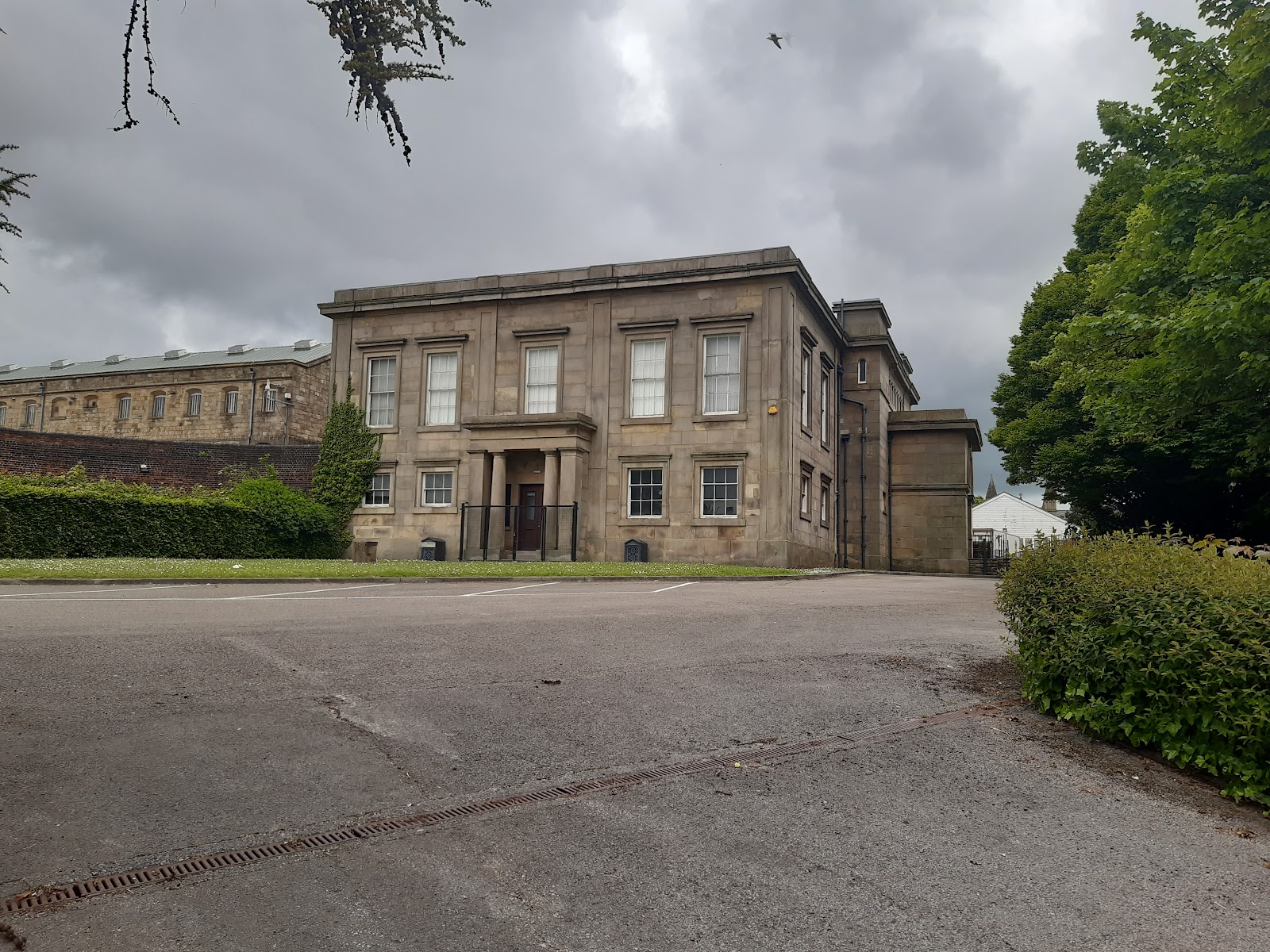
This was where court cases were heard before the current building next to the Harris Library was built. It was constructed in 1829, replacing an earlier building within the gaol, which this backs on to. It was later used as a drill hall, and is now part of the Museum of Lancashire. The museum is currently closed due to lack of funding from the council, though there are still hopes it may reopen.
New Hall Lane
The Rose Bud, sometimes considered to be 1 London Road, sometime number 2 New Hall Lane, was on the corner on the south side; it closed in 1988, and demolished to widen the road. Image here.
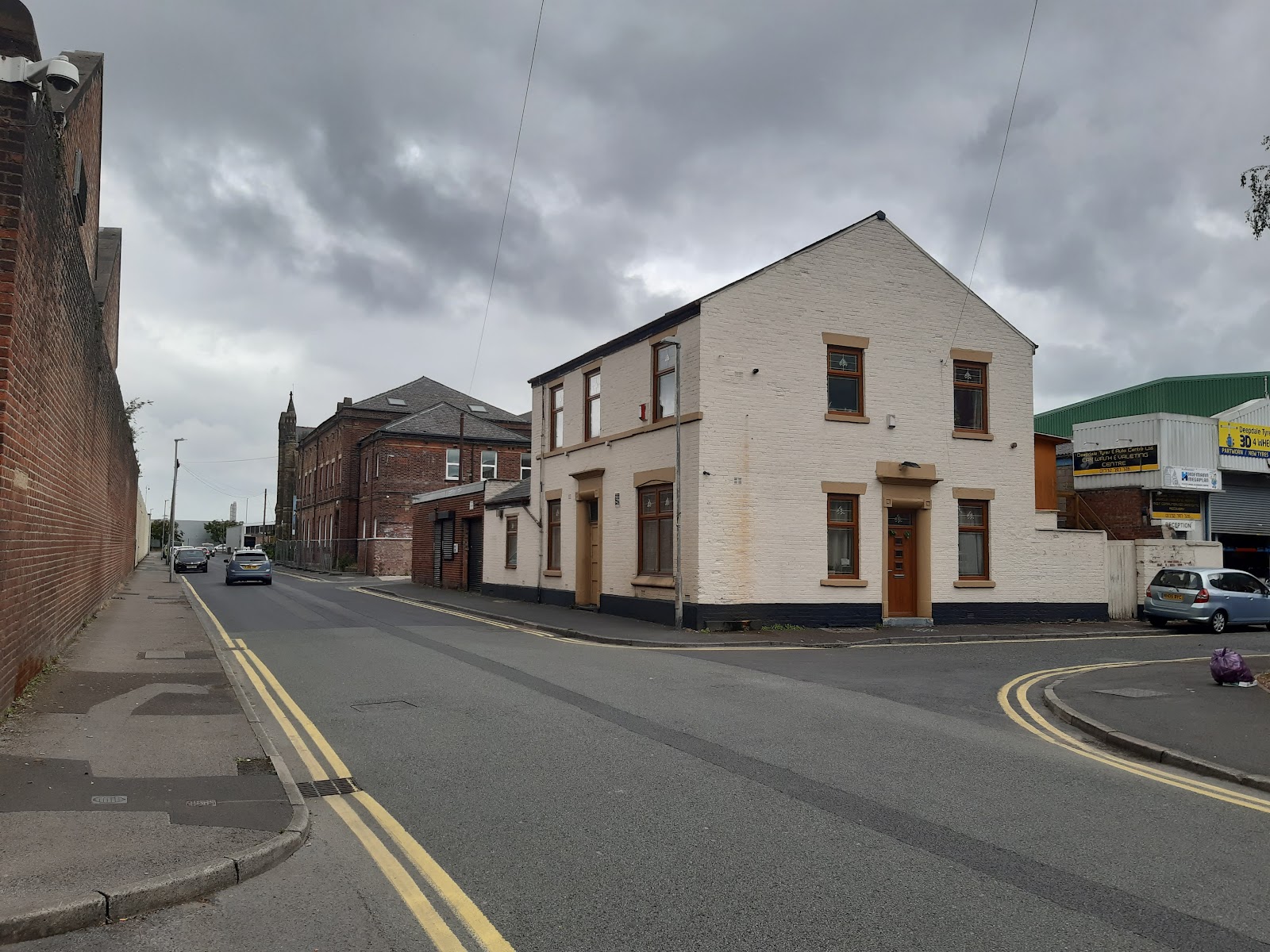
The Barley Mow, number 5, was a very short way down on the left, it is the second building. A photo from 1905 here, looks like it did not last much beyond that, possibly becoming an army recruitment place; there were two drill halls behind it (including the Old Sessions House). I did not get a great photo, as there was a van right outside - it is the two-storey building beyond the off-licence.

The Peel's Arms was at number 30, but closed around the same time as the Barley Mow.
On the left now is St Mary's Street, which connects back to Ribbleton Lane. Named after St Mary's church, which is still standing, though closed, and is on the left, before the high wall of the prison.

Opposite the start of the prison was St Mary's pub, a school just beyond it, and a Methodist church further still. None are still open for their original function.
The Carter's Arms was at 36, on Adelaide Street. Looks like this got rebuilt in the sixties or seventies. The original and pre-fab replacement can be seen here. Closed in the early eighties
Queen Adelaide was on the other corner of Adelaide Street, at number 40, images here and here. Still standing.

On the left there are a couple of mills. First Preston New Mills, built 1891 which is L-shaped, with only a short frontage on New Hall Lane; that section is now a hotel, and I think was built later, to judge by this image. Then Centenary Mill, built 1895 and pictured below, which is Grade 2 listed, still standing, though used as apartments.
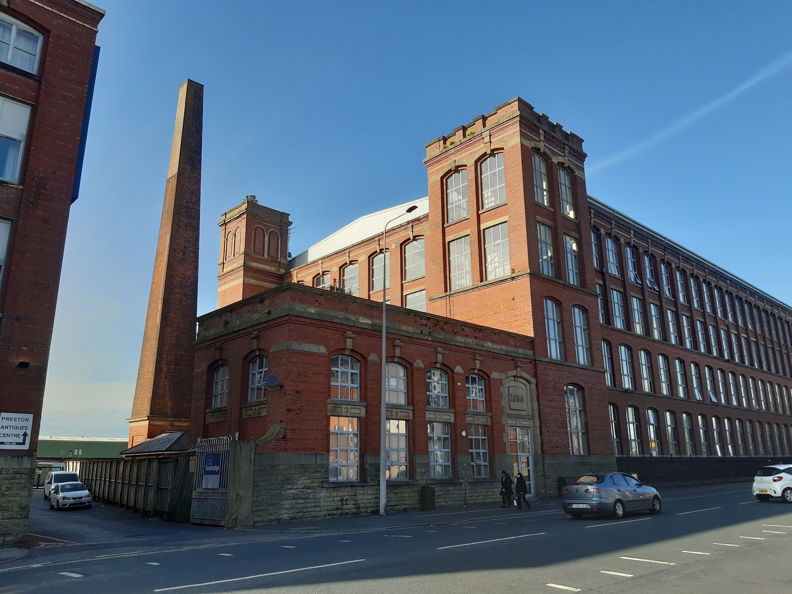
Centenary Mill had an impressive iron arch, giving the adjacent road the name Arch Street. It can be seen in the photo below, which also shows how parts of New Hall Lane have been greatly improved visually recently.

The General Codrington, number 56, corner of Napier Street, image here. Closed maybe 1948 or 1988.
The New Hall Lane Tavern, number 60 or 62, was formerly the Halfway House, on the corner of Aspden Street. Image here.
The Gibraltar was at number 82, corner of Pakington Street, closed in the early-eighties and since demolished. Image here. This area has been fully redeveloped, and there is no sign of any of these three pubs.
The Birley Arms at number 100, corner of Fishwick road, is now Steak House Saloon. Old image here.

There used to be a cinema on the site of the garage opposite.
The Belle Vue Hotel was on the left, corner of Bootle Street - though in my head I have always thought of it as on the corner of Skeffington Road. The building is now "Maya Delikatesy". It was not an attractive pub, but this was my local when I first moved to Preston. My most distinct memory of it was "Love is all around us" playing on the juke box all the time...
A photo of it from better times here. See also here.

St Matthew's church is on the left. I used to live on Derby Square, just behind the church; it is more of a backwards lowercase H than a square. The church seems to still be open.

The Acregate closed in 2008, and I think is being converted to accommodation. Another I visited when I lived in the area, though not often.

Acregate Lane connects New Hall Lane to Ribbleton Lane, opposite where the Old England stood. A short way up on the left hand side was Preston Greyhound Stadium, built by the Preston Greyhound Racing Association. It opened in 1932, and was so successful the company built a second stadium in Derby - in the old gaol - the following year. Curiously both closed in 1988. There is now a housing estate on the site, Canterbury Road and Harling Road.

Back to New Hall Lane, and there is a small park, Ribbleton Park, on the left.

Quite a bit further along in the Hesketh's Arms - out of over two dozen pubs along these two roads, this is the only one still open.


Comments
Post a Comment