Bridges Over the Lancaster Canal
This is a list of bridges over the north section of the canal, in order, from south to north.
Please note that this is a work in progress!
The first ten no longer exist, as the canal has been truncated. The numbers are therefore somewhat speculative.
A map with each extant bridge marked can be found here.
Bridges 1-3(?)

The map shows the Preston terminus of the canal in 1909. The first three bridges were all for sidings for the railway connections, which indicates the numbers were introduced after the railway was built.
Bridge 4(?), Marsh Lane, formerly Bridge Lane

This is the remains of the bridge (also visible on the map above). It looks like it was steel, and three spans, the nearest over a railway siding, the middle over the canal, the further was filled in, at least in later life. I would guess this was not the original bridge, which would have been stone like all the rest.
How it used to look here, and an aeriel view here.
Bridge 5(?)
Bridge 6(?), Maudlands Road

This is still in good condition, though I think the canal itself is buried. A plaque indicates it is still maintained by the railway, but the land to the right is UCLan now.
How it used to look here.
Bridge 7(?), Preston and Longridge Railway

This is the trackbed of the Preston and Longridge Railway, built around 1840 or 50 to connect the existing route to the rest of the network. In the distance you can see where it went into Miley Tunnel. The track was still in place in the mid-nineties.
The canal bridge is evidenced by the sections of iron on ether side of the track.
There is a side view here, taken in 2007, showing water under it, but a grass bank behind it, where the canal has been filled in. The land to the right of my image is now part of UCLan, and the water is long gone, I suspect.
Bridge 8(?), Moss Bridge (under Fylde Road)

There is little left, with the canal being filled in, but I think the iron railings between the two brick abutments are the remains of the bridge.
You can see the bridge in the bottom right of this aerial view.
Bridge 9(?), Fylde Road Viaduct

But the viaduct continues to the north (right in the image above), over a series of arches, the last of which was over the canal.

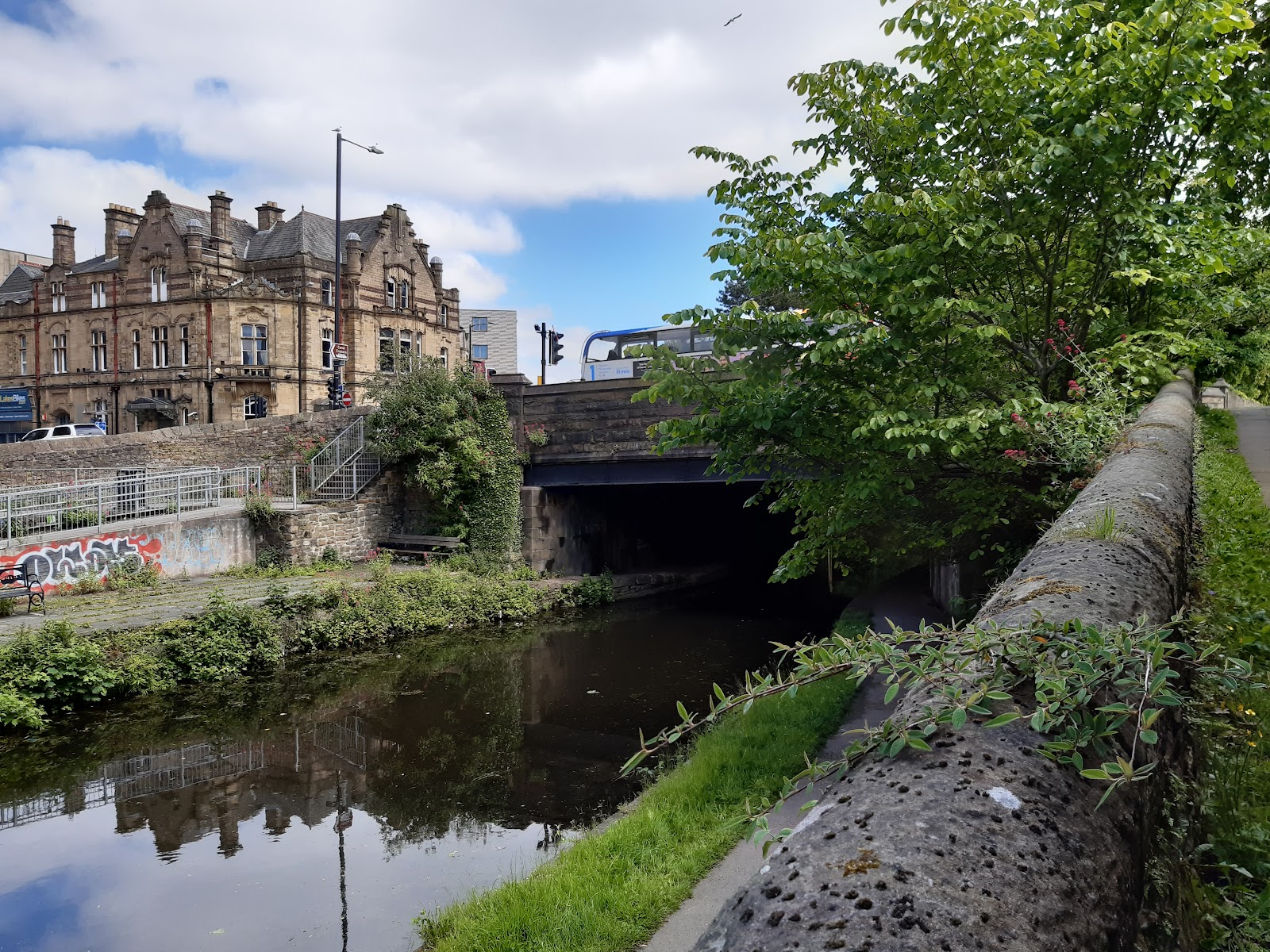
Bridge 10(?), the aqueduct over aqueduct Street

There is an image here. An article here describes an attempt to blow the aqueduct up in 1887, which would have emptied some 46 miles of canal into Preston - or at least the lower lying parts.
Bridge 11, originally Stock's Bridge, now Roebuck Street Bridge

This got widened between 1909 and 1929, but the original structure is still visible, buried inside the new
Bridge 11a, Blackpool Road

A later addition. Blackpool Road was built in the earlier twenties, according to here.
Bridge 12, Woodplumpton Road

Bridge 13, Savick Aqueduct

Where the canal crosses the Savick Brook; Not easy to get to!
Bridge 14, Hollinshead Fold
Bridge 14a, Hollinshead Fold Aqueduct

The number suggests this was a later addition, which surely cannot be the case?
Bridge 15, Ingol Ashes

Bridge 16, Cottam Mill

Tom Benson Way

Another later bridge, built 1985, so rather more recent than Blackpool Road, and as far as I know, too late to get a number, even one suffixed by a letter.
Bridge 17, Cottam Hall

Bridge 18, Malt Kiln (Lea Road)

Bridge 19, Quakers

Bridge 20, Turn

The bridge no longer exists, but you can see in the image where the canal narrows for it. Besides that, even the approaches have gone. Not sure when it disappeared; it was still there on maps in 1938.
Preston Western Distributor


Bridge 21, Bryars

Why is this a wooden bridge when all the rest are stone? I am guessing the original collapsed, and this is a cheap replacement.
Bridge 22, Lea Lane

Of the original bridges, this is one of the busiest, and it is not unknown for vehicles to knock a few stones off it every now and again; the ones on the top left in the image are only a couple of years old.
Bridge 23, Ward's House

Bridge 24, Salwick Hall

Bridge 25, Wilson's Bridge

Bridge 26, Salwick Bridge

Bridge 27, Six Mile Bridge
Because it is six miles from Preston, I guess...
Bridge 28, New Bridge
M55
Built - or at least opened - in 1975.
Bridge 29, Kellets Bridge
Bridge 30, Roots Bridge

Takes its name from Roots Lane, which crosses it.
Bridge 31, Stone Chimney Bridge
This is on Blackleach Lane; I guess they thought Stone Chimney Bridge sounds nicer. There is a terrace of houses just north east of the bridge that looks to be called Stone Chimneys on old maps. The marina, which is just beyond the bridge on the left, is, nevertheless, called Blackleach Marina.
Bridge 32, Swillbrook Bridge

This is the main road into Catforth.
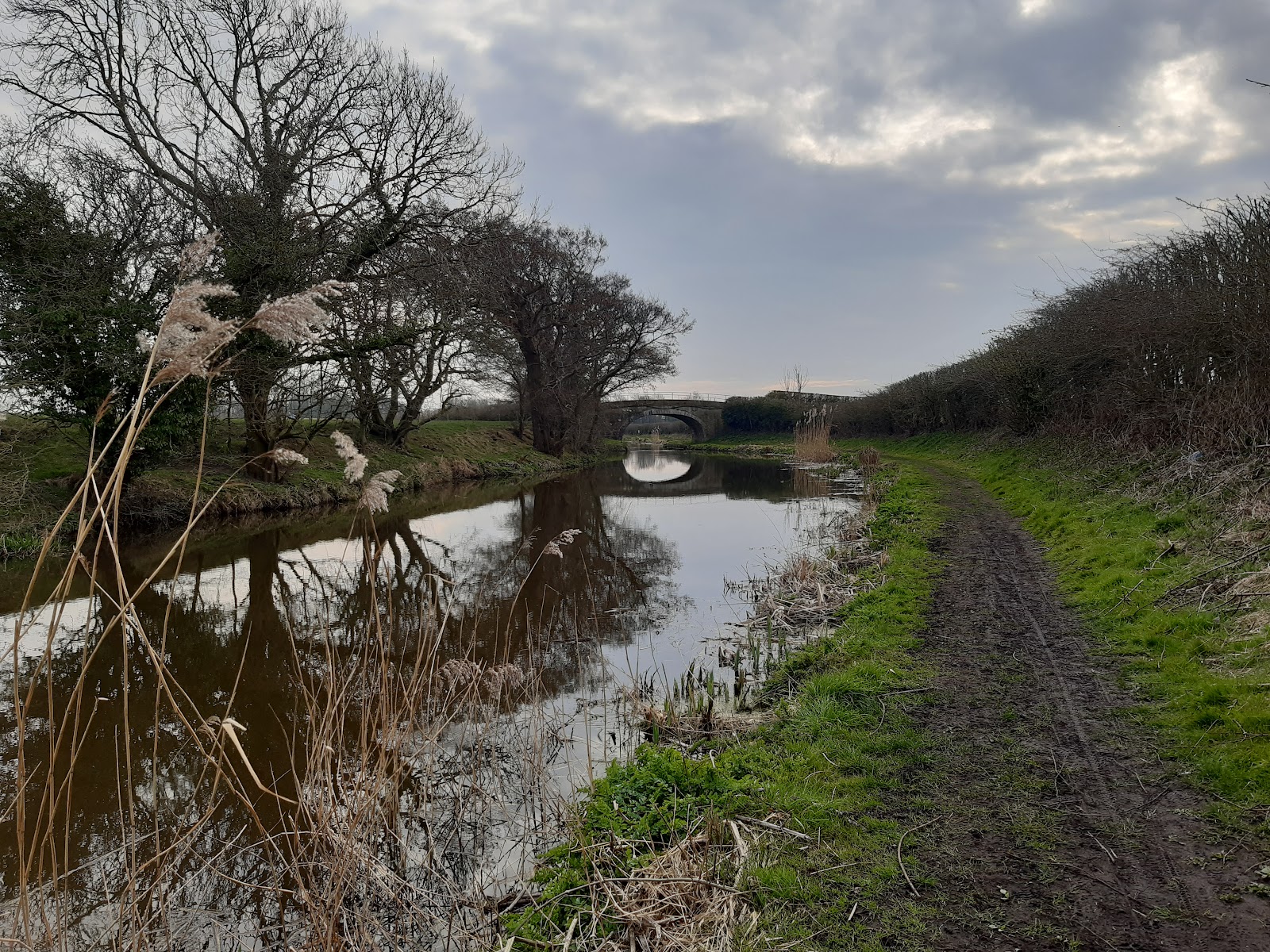
Some outstanding here...
Bridge 86, Galgate Bridge

Bridge 87, Conder Aqueduct

The canal crosses the river Conder.
Bridge 88, Ellel Hall Bridge

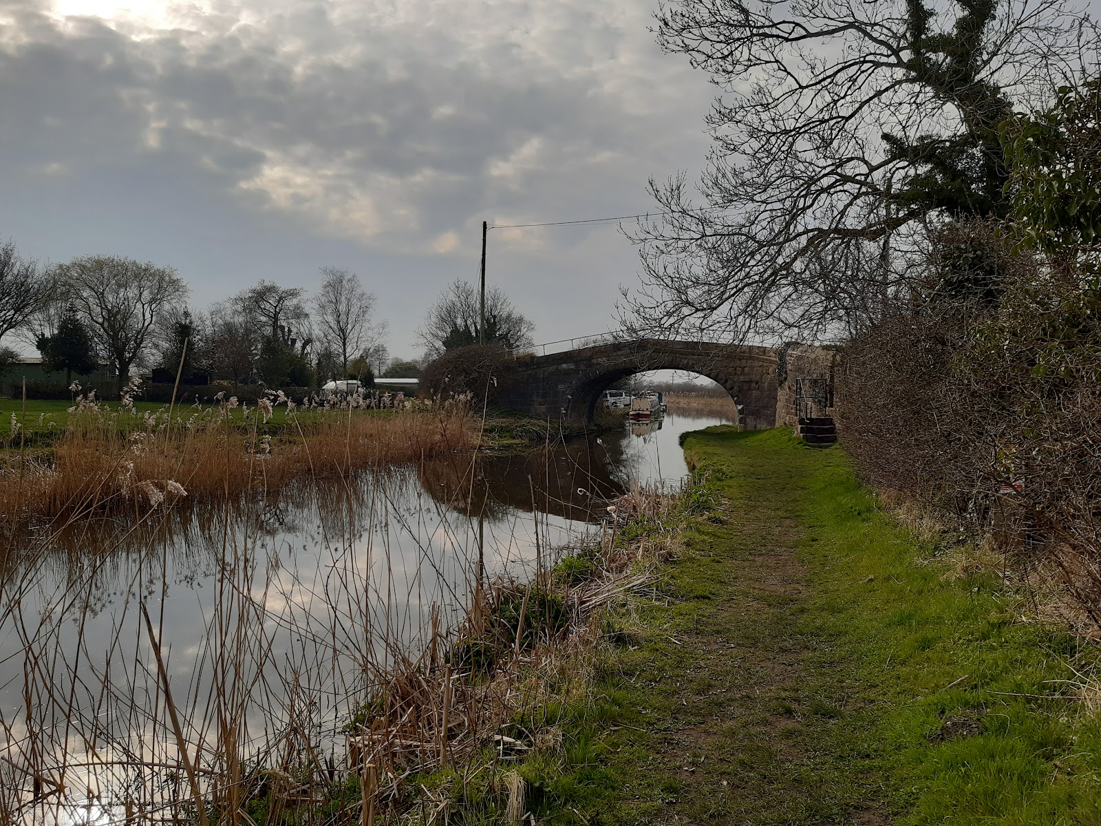
Some outstanding here...
Bridge 97, Railway Bridge

Somewhat in the distance, but it is there!
Bridge 98, Basin Bridge

Bridge 98a, Water Witch footbridge
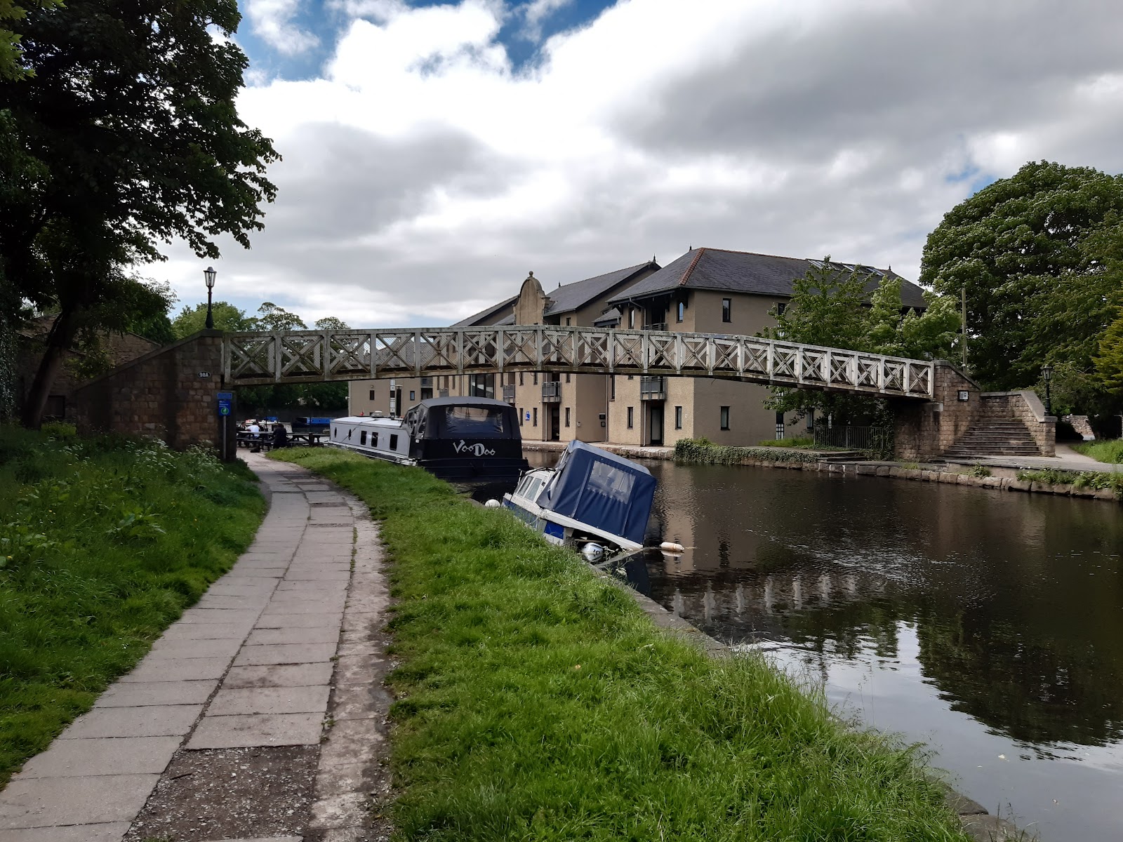
Clearly a later bridge, given its number, it does not appear on maps as recently as 1938. There are two basins here, where the coal wharves for Lancaster were. On the left were stables, converted in 1978 into a pub called the Water Witch. Whether the pub takes its name from the footbridge, or the footbridge from the pub, or both from elsewhere I have been unable to find out.

This bonus image shows the pub. The building behind it, covered in scaffolding, in part of the hospital.
Bridge 99, Penny Street
Penny Street is the A6, the major route through Lancaster.
Bridge 100, Friarage Bridge

Clearly not the original bridge. Just left on the photo is the catholic cathedral, and I guess "friarage" is a alternative name for friary.
Bridge 101, Nelson Street

You can see the original structure underneath the later iron bridge, which is helpfully dated to 1876.
Bridge 102, Moor Lane

Again, you can see the original structure underneath the later iron bridge; I would guess this is quite more recent than the previous, though obviously not that modern.
Bridge 103, Shaw Street Bridge?

This is clearly not the original structure, but it is odd the canal does not narrow at this point.
Bridge 104, Ridge Lane Bridge

Featuring some colourful graffiti, this concrete bridge must also be a later replacement, but in this instance, the canal does narrow.
Bridge 105, Dolphin Lea Bridge

I think this gets its name from Dolphinlee, a house or farm that was about half a mile to the east, pretty much the south end of junction 34 of the M6, and a map from 1910 calls it Dolphinlee Bridge.
There is a new Dolphinlee House just to the southeast, for "assisted living"; this is a modern building that presumably gets its name from the bridge or older building. There is also a village called Dolphinholme, apparently a Norse name, about five miles south of Lancaster; the bridge cannot get its name directly from there, but there may be a link.Unnamed footbridge

As I approached this footbridge, I felt sure it must be closed, as it looked so insubstantial and decrepit, but there is nothing on it to suggest that is the case.
Bridge 106, Bulk Road Aqueduct

This takes the canal over the A589, the main road from Lancaster to the motorway network. This is also a replacement for the original.
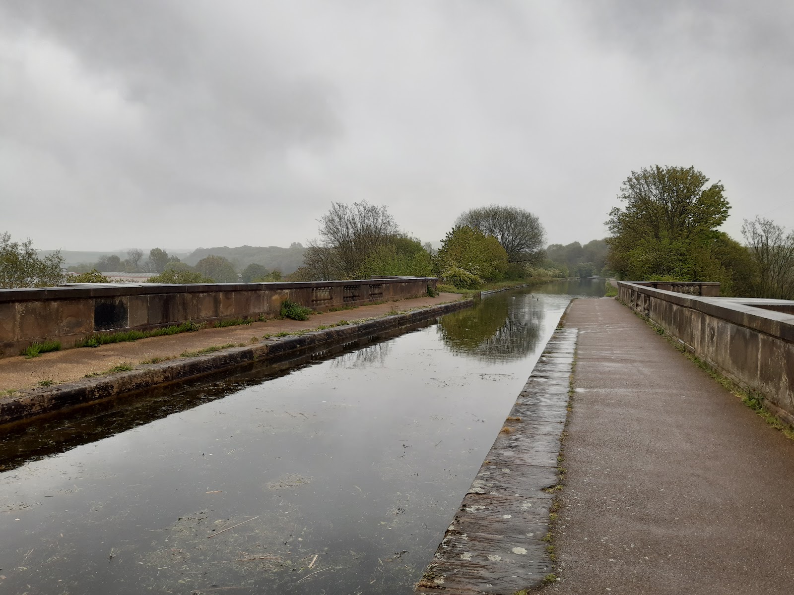
Bridge 107, Lune Aqueduct

This is the most spectacular bridge on the canal, the only one that really stands out. A similar was supposed to span the Ribble, but it never happened.
Bridge 108, Halton Road Bridge

Bridges 109+
May or may not get done...
Bridge 186, Change Bridge

We are now in Kendal, and the canal has been filled in, but the bridge is in good condition, and still displays its number. A change bridge allows the tow path to swap from one side to the other - this is the only one in Cumbria,
Bridge 187(?)


Comments
Post a Comment